

Pacific Trade Winds Biome
357
0
50
100
150
200
0
5
10
15
20
Climatology (years)
Depth (m)
Production at DCM (%)
Zm (sigma)
Zeu
Pt (at DCM)
0.00
0.20
0.40
0.60
0.80
1.00
0.00
0.15
0.30
0.45
0.60
0.75
SeaWiFS (TASM): September 1997 - January 2002
Surface Chl (mg m -3
)
Pt d
-1
Chl m
-3
Pt (gC m
-2
d
-1
)
1998
1999
2000
2001
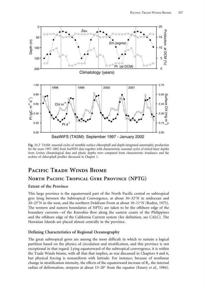
Fig. 11.7 TASM: seasonal cycles of monthly surface chlorophyll and depth-integrated autotrophic production
for the years 1997–2002 from SeaWiFS data together with characteristic seasonal cycles of mixed-layer depths
from Levitus climatological data and photic depths were computed from characteristic irradiance and the
archive of chlorophyll profiles discussed in Chapter 1.
Pacific Trade Winds Biome
North Pacific Tropical Gyre Province (NPTG)
Extent of the Province
This large province is the equatorward part of the North Pacific central or subtropical
gyre lying between the Subtropical Convergence, at about 30–32
N in midocean and
20–25
N in the west, and the northern Doldrum Front at about 10–11
N (Roden, 1975).
The western and eastern boundaries of NPTG are taken to be the offshore edge of the
boundary currents—of the Kuroshio flow along the eastern coasts of the Philippines
and the offshore edge of the California Current system (for definition, see CALC). The
Hawaiian Islands are placed almost centrally in the province.
Defining Characteristics of Regional Oceanography
The great subtropical gyres are among the most difficult in which to sustain a logical
partition based on the physics of circulation and stratification, and this province is not
exceptional in that regard. Lying equatorward of the subtropical convergence, it is within
the Trade Winds biome, with all that that implies, as was discussed in Chapters 4 and 6,
but physical forcing is nonuniform with latitude. For instance, because of nonlinear
change in stratification intensity, the effects of the equatorward increase of R i , the internal
radius of deformation, steepens at about 15–20
from the equator (Emery et al., 1984).
357
0
50
100
150
200
0
5
10
15
20
Climatology (years)
Depth (m)
Production at DCM (%)
Zm (sigma)
Zeu
Pt (at DCM)
0.00
0.20
0.40
0.60
0.80
1.00
0.00
0.15
0.30
0.45
0.60
0.75
SeaWiFS (TASM): September 1997 - January 2002
Surface Chl (mg m -3
)
Pt d
-1
Chl m
-3
Pt (gC m
-2
d
-1
)
1998
1999
2000
2001
Fig. 11.7 TASM: seasonal cycles of monthly surface chlorophyll and depth-integrated autotrophic production
for the years 1997–2002 from SeaWiFS data together with characteristic seasonal cycles of mixed-layer depths
from Levitus climatological data and photic depths were computed from characteristic irradiance and the
archive of chlorophyll profiles discussed in Chapter 1.
Pacific Trade Winds Biome
North Pacific Tropical Gyre Province (NPTG)
Extent of the Province
This large province is the equatorward part of the North Pacific central or subtropical
gyre lying between the Subtropical Convergence, at about 30–32
N in midocean and
20–25
N in the west, and the northern Doldrum Front at about 10–11
N (Roden, 1975).
The western and eastern boundaries of NPTG are taken to be the offshore edge of the
boundary currents—of the Kuroshio flow along the eastern coasts of the Philippines
and the offshore edge of the California Current system (for definition, see CALC). The
Hawaiian Islands are placed almost centrally in the province.
Defining Characteristics of Regional Oceanography
The great subtropical gyres are among the most difficult in which to sustain a logical
partition based on the physics of circulation and stratification, and this province is not
exceptional in that regard. Lying equatorward of the subtropical convergence, it is within
the Trade Winds biome, with all that that implies, as was discussed in Chapters 4 and 6,
but physical forcing is nonuniform with latitude. For instance, because of nonlinear
change in stratification intensity, the effects of the equatorward increase of R i , the internal
radius of deformation, steepens at about 15–20
from the equator (Emery et al., 1984).