

330
Chapter 11: The Pacific Ocean
strong thermal gradient across the pycnocline. The “cold belt,” or bottom layer, may take
temperatures < 2
C even in summer; nutrient levels are high in the bottom layer, and
rapidly exhausted in the surface layer.
A more complex (50-km wide) shelf-break front with a strong salinity gradient occurs
along the 200-m isobath and can be traced into the western Bering Sea marking the
transition between the isohaline oceanic water of the deep basin and the shelf waters that
have important horizontal salinity gradients. Seaward of the shelf-break front, flow is
consistently to the northwest around the central gyre, as part of the Bering Slope Current,
whereas, inshore of this front, the flow is dominated by tidal forcing and is primarily
cross-shelf. In the outer shelf domain, between middle and shelf-break fronts, strong flow
generally follows the 100-m isobath, generating meanders that force eddies up over the
shelf; subsurface water below the winter mixed layer is relatively warm.
Defining Characteristics of Regional Oceanography
All modern accounts of this region emphasize the variability of conditions here and
describe major interannual fluctuations in the physical—and hence ecological—regime;
these fluctuations respond both to the Southern Oscillation and to the longer-term
changes, decadal or secular, of mean global temperature.
Each sea lies behind a long island arc: the Bering Sea is separated from the Pacific
by the Aleutian Islands, the Okhotsk Sea by the Kurils. Flow from the Alaska Stream
into the central gyre of the Bering Sea occurs through the western passages; through
Near Strait, the flow is almost directly into the East Kamchatka Current, whereas the
Bering Slope Current, the deep eastern limb of the cyclonic gyre, is fed through Amchitka
Pass (Favorite, 1974; Stabeno and Reed, 1994). Flow from the Bering Sea northward,
forced by a 0.5-m difference in elevation between Pacific and Arctic Oceans, originates
in continental shelf water passing around the northern limb of the central gyre and into
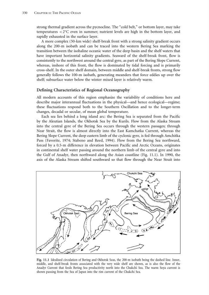
the Gulf of Anadyr, then northward along the Asian coastline (Fig. 11.1). In 1990, the
axis of the Alaska Stream shifted southward so that flow through the Near Strait into
Fig. 11.1 Idealized circulation of Bering and Okhotsk Seas, the 200-m isobath being the dashed line. Inner,
middle, and shelf-break fronts associated with the very wide shelf are shown, as is also the flow of the
Anadyr Current that feeds Bering Sea productivity north into the Chukchi Sea. The warm Soya current is
shown passing from the Sea of Japan into the rim current of the Chukchi Sea.
Chapter 11: The Pacific Ocean
strong thermal gradient across the pycnocline. The “cold belt,” or bottom layer, may take
temperatures < 2
C even in summer; nutrient levels are high in the bottom layer, and
rapidly exhausted in the surface layer.
A more complex (50-km wide) shelf-break front with a strong salinity gradient occurs
along the 200-m isobath and can be traced into the western Bering Sea marking the
transition between the isohaline oceanic water of the deep basin and the shelf waters that
have important horizontal salinity gradients. Seaward of the shelf-break front, flow is
consistently to the northwest around the central gyre, as part of the Bering Slope Current,
whereas, inshore of this front, the flow is dominated by tidal forcing and is primarily
cross-shelf. In the outer shelf domain, between middle and shelf-break fronts, strong flow
generally follows the 100-m isobath, generating meanders that force eddies up over the
shelf; subsurface water below the winter mixed layer is relatively warm.
Defining Characteristics of Regional Oceanography
All modern accounts of this region emphasize the variability of conditions here and
describe major interannual fluctuations in the physical—and hence ecological—regime;
these fluctuations respond both to the Southern Oscillation and to the longer-term
changes, decadal or secular, of mean global temperature.
Each sea lies behind a long island arc: the Bering Sea is separated from the Pacific
by the Aleutian Islands, the Okhotsk Sea by the Kurils. Flow from the Alaska Stream
into the central gyre of the Bering Sea occurs through the western passages; through
Near Strait, the flow is almost directly into the East Kamchatka Current, whereas the
Bering Slope Current, the deep eastern limb of the cyclonic gyre, is fed through Amchitka
Pass (Favorite, 1974; Stabeno and Reed, 1994). Flow from the Bering Sea northward,
forced by a 0.5-m difference in elevation between Pacific and Arctic Oceans, originates
in continental shelf water passing around the northern limb of the central gyre and into
the Gulf of Anadyr, then northward along the Asian coastline (Fig. 11.1). In 1990, the
axis of the Alaska Stream shifted southward so that flow through the Near Strait into
Fig. 11.1 Idealized circulation of Bering and Okhotsk Seas, the 200-m isobath being the dashed line. Inner,
middle, and shelf-break fronts associated with the very wide shelf are shown, as is also the flow of the
Anadyr Current that feeds Bering Sea productivity north into the Chukchi Sea. The warm Soya current is
shown passing from the Sea of Japan into the rim current of the Chukchi Sea.