

304
Chapter 10: The Indian Ocean
0
20
40
60
80
100
0
0.1
0.2
0.3
0.4
0.5
Climatology (years)
Depth (m)
Production at DCM (%)
Zm (sigma)
Zeu
Pt (at DCM)
0.0
0.4
0.7
1.0
1.4
1.8
0.0
0.5
1.0
1.5
2.0
2.5
SeaWiFS (ARAB): September 1997 - January 2002
Surface Chl (mg m -3
)
Pt (gC m
-2
d
-1
)
Pt d
-1
Chl m
-3
1998
1999
2000
2001
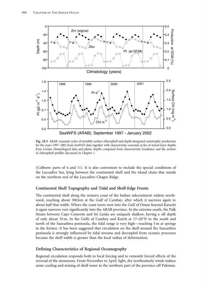
Fig. 10.5 ARAB: seasonal cycles of monthly surface chlorophyll and depth-integrated autotrophic production
for the years 1997–2002 from SeaWiFS data together with characteristic seasonal cycles of mixed-layer depths
from Levitus climatological data and photic depths computed from characteristic irradiance and the archive
of chlorophyll profiles discussed in Chapter 1.
(Colborn: parts of 4 and 11). It is also convenient to include the special conditions of
the Laccadive Sea, lying between the continental shelf and the island chain that stands
on the northern end of the Laccadive-Chagos Ridge.
Continental Shelf Topography and Tidal and Shelf-Edge Fronts
The continental shelf along the western coast of the Indian subcontinent widens northward, reaching about 300 km at the Gulf of Cambay, after which it narrows again to
about half that width. Where the coast turns west into the Gulf of Oman beyond Karachi
it again narrows very significantly into the ARAB province. In the extreme south, the Palk
Straits between Cape Comorin and Sri Lanka are uniquely shallow, having a sill depth
of only about 10 m. In the Gulfs of Cambay and Kutch at 17–20
N to the south and
north of the Saurashtra peninsula, the tidal range is very high—reaching 5 m at springs
in the former. It has been suggested that circulation on the shelf around the Saurashtra
peninsula is strongly influenced by tidal streams and decoupled from oceanic processes
because the shelf width is greater than the local radius of deformation.
Defining Characteristics of Regional Oceanography
Regional circulation responds both to local forcing and to remotely forced effects of the
reversal of the monsoons. From November to April, light, dry northeasterly winds induce
some cooling and mixing of shelf water in the northern part of the province off Pakistan.
Chapter 10: The Indian Ocean
0
20
40
60
80
100
0
0.1
0.2
0.3
0.4
0.5
Climatology (years)
Depth (m)
Production at DCM (%)
Zm (sigma)
Zeu
Pt (at DCM)
0.0
0.4
0.7
1.0
1.4
1.8
0.0
0.5
1.0
1.5
2.0
2.5
SeaWiFS (ARAB): September 1997 - January 2002
Surface Chl (mg m -3
)
Pt (gC m
-2
d
-1
)
Pt d
-1
Chl m
-3
1998
1999
2000
2001
Fig. 10.5 ARAB: seasonal cycles of monthly surface chlorophyll and depth-integrated autotrophic production
for the years 1997–2002 from SeaWiFS data together with characteristic seasonal cycles of mixed-layer depths
from Levitus climatological data and photic depths computed from characteristic irradiance and the archive
of chlorophyll profiles discussed in Chapter 1.
(Colborn: parts of 4 and 11). It is also convenient to include the special conditions of
the Laccadive Sea, lying between the continental shelf and the island chain that stands
on the northern end of the Laccadive-Chagos Ridge.
Continental Shelf Topography and Tidal and Shelf-Edge Fronts
The continental shelf along the western coast of the Indian subcontinent widens northward, reaching about 300 km at the Gulf of Cambay, after which it narrows again to
about half that width. Where the coast turns west into the Gulf of Oman beyond Karachi
it again narrows very significantly into the ARAB province. In the extreme south, the Palk
Straits between Cape Comorin and Sri Lanka are uniquely shallow, having a sill depth
of only about 10 m. In the Gulfs of Cambay and Kutch at 17–20
N to the south and
north of the Saurashtra peninsula, the tidal range is very high—reaching 5 m at springs
in the former. It has been suggested that circulation on the shelf around the Saurashtra
peninsula is strongly influenced by tidal streams and decoupled from oceanic processes
because the shelf width is greater than the local radius of deformation.
Defining Characteristics of Regional Oceanography
Regional circulation responds both to local forcing and to remotely forced effects of the
reversal of the monsoons. From November to April, light, dry northeasterly winds induce
some cooling and mixing of shelf water in the northern part of the province off Pakistan.