

258
Chapter 9: The Atlantic Ocean
0
20
40
60
80
100
0
5
10
15
20
25
30
Climatology (years)
Depth (m)
Production at DCM (%)
Zm (sigma)
Zeu
Pt (at DCM)
0.00
0.30
0.60
0.90
1.20
1.50
0.30
0.60
0.90
1.20
1.50
SeaWiFS (NWCS): September 1997 - January 2002
Surface Chl (mg m -3
)
Pt d
-1
Chl m
-3
Pt (gC m
-2
d
-1
)
1998
1999
2000
2001
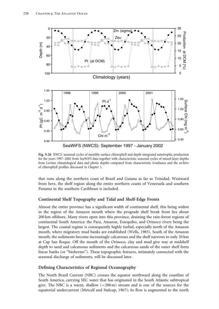
Fig. 9.26 NWCS: seasonal cycles of monthly surface chlorophyll and depth-integrated autotrophic production
for the years 1997–2002 from SeaWiFS data together with characteristic seasonal cycles of mixed-layer depths
from Levitus climatological data and photic depths computed from characteristic irradiance and the archive
of chlorophyll profiles discussed in Chapter 1.
that runs along the northern coast of Brazil and Guiana as far as Trinidad. Westward
from here, the shelf region along the entire northern coasts of Venezuela and southern
Panama in the southern Caribbean is included.
Continental Shelf Topography and Tidal and Shelf-Edge Fronts
Almost the entire province has a significant width of continental shelf, this being widest
in the region of the Amazon mouth where the prograde shelf break front lies about
200 km offshore. Many rivers open into this province, draining the rain-forest regions of
continental South America: the Para, Amazon, Essequibo, and Orinoco rivers being the
largest. The coastal regime is consequently highly turbid, especially north of the Amazon
mouth, where migratory mud banks are established (Wells, 1983). South of the Amazon
mouth, the sediments become increasingly calcareous and the shelf narrows to only 20 km
at Cap San Roque. Off the mouth of the Orinoco, clay and mud give way at midshelf
depth to sand and calcareous sediments and the calcareous sands of the outer shelf form
linear banks (or “bioherms”). These topographic features, intimately connected with the
seasonal discharge of sediments, will be discussed later.
Defining Characteristics of Regional Oceanography
The North Brazil Current (NBC) crosses the equator northward along the coastline of
South America, carrying SEC water that has originated in the South Atlantic subtropical
gyre. The NBC is a warm, shallow (<200 m) stream and is one of the sources for the
equatorial undercurrent (Metcalf and Stalcup, 1967); its flow is augmented to the north
Chapter 9: The Atlantic Ocean
0
20
40
60
80
100
0
5
10
15
20
25
30
Climatology (years)
Depth (m)
Production at DCM (%)
Zm (sigma)
Zeu
Pt (at DCM)
0.00
0.30
0.60
0.90
1.20
1.50
0.30
0.60
0.90
1.20
1.50
SeaWiFS (NWCS): September 1997 - January 2002
Surface Chl (mg m -3
)
Pt d
-1
Chl m
-3
Pt (gC m
-2
d
-1
)
1998
1999
2000
2001
Fig. 9.26 NWCS: seasonal cycles of monthly surface chlorophyll and depth-integrated autotrophic production
for the years 1997–2002 from SeaWiFS data together with characteristic seasonal cycles of mixed-layer depths
from Levitus climatological data and photic depths computed from characteristic irradiance and the archive
of chlorophyll profiles discussed in Chapter 1.
that runs along the northern coast of Brazil and Guiana as far as Trinidad. Westward
from here, the shelf region along the entire northern coasts of Venezuela and southern
Panama in the southern Caribbean is included.
Continental Shelf Topography and Tidal and Shelf-Edge Fronts
Almost the entire province has a significant width of continental shelf, this being widest
in the region of the Amazon mouth where the prograde shelf break front lies about
200 km offshore. Many rivers open into this province, draining the rain-forest regions of
continental South America: the Para, Amazon, Essequibo, and Orinoco rivers being the
largest. The coastal regime is consequently highly turbid, especially north of the Amazon
mouth, where migratory mud banks are established (Wells, 1983). South of the Amazon
mouth, the sediments become increasingly calcareous and the shelf narrows to only 20 km
at Cap San Roque. Off the mouth of the Orinoco, clay and mud give way at midshelf
depth to sand and calcareous sediments and the calcareous sands of the outer shelf form
linear banks (or “bioherms”). These topographic features, intimately connected with the
seasonal discharge of sediments, will be discussed later.
Defining Characteristics of Regional Oceanography
The North Brazil Current (NBC) crosses the equator northward along the coastline of
South America, carrying SEC water that has originated in the South Atlantic subtropical
gyre. The NBC is a warm, shallow (<200 m) stream and is one of the sources for the
equatorial undercurrent (Metcalf and Stalcup, 1967); its flow is augmented to the north