

Atlantic Coastal Biome
241
and polychaete abundance is clearly forced by the relative supply of POC, of all sorts,
raining from the pelagial onto the benthic ecosystem. This is not exactly news, but has
not often been observed in tropical seas.
Synopsis
Case 5—Large-amplitude response to monsoon-like reversal of trade winds, but modified by
coastal processes—Generalizations concerning the calendar of this province are unsatisfactory, because of the major differences between the Guinean and Central African coasts,
and the difficulty of separating processes in the latter from the effects of the Angola
Dome, offshore. In hindsight it would have been preferable to recognize two separate
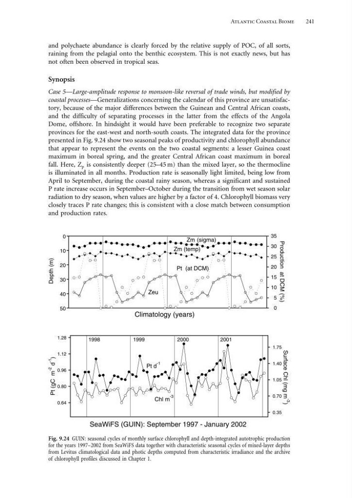
provinces for the east-west and north-south coasts. The integrated data for the province
presented in Fig. 9.24 show two seasonal peaks of productivity and chlorophyll abundance
that appear to represent the events on the two coastal segments: a lesser Guinea coast
maximum in boreal spring, and the greater Central African coast maximum in boreal
fall. Here, Z p is consistently deeper (25–45 m) than the mixed layer, so the thermocline
is illuminated in all months. Production rate is seasonally light limited, being low from
April to September, during the coastal rainy season, whereas a significant and sustained
P rate increase occurs in September–October during the transition from wet season solar
radiation to dry season, when values are higher by a factor of 4. Chlorophyll biomass very
closely traces P rate changes; this is consistent with a close match between consumption
and production rates.
0.64
0.80
0.96
1.12
1.28
0.35
0.70
1.05
1.40
1.75
SeaWiFS (GUIN): September 1997 - January 2002
Surface Chl (mg m -3
)
Pt d
-1
Chl m
-3
1998
1999
2000
2001
Pt (gC m
-2
d
-1
)
0
10
20
30
40
50
0
5
10
15
20
25
30
35
Climatology (years)
Depth (m)
Production at DCM (%)
Zm (sigma)
Zeu
Pt (at DCM)
Zm (temp)
Fig. 9.24 GUIN: seasonal cycles of monthly surface chlorophyll and depth-integrated autotrophic production
for the years 1997–2002 from SeaWiFS data together with characteristic seasonal cycles of mixed-layer depths
from Levitus climatological data and photic depths computed from characteristic irradiance and the archive
of chlorophyll profiles discussed in Chapter 1.
241
and polychaete abundance is clearly forced by the relative supply of POC, of all sorts,
raining from the pelagial onto the benthic ecosystem. This is not exactly news, but has
not often been observed in tropical seas.
Synopsis
Case 5—Large-amplitude response to monsoon-like reversal of trade winds, but modified by
coastal processes—Generalizations concerning the calendar of this province are unsatisfactory, because of the major differences between the Guinean and Central African coasts,
and the difficulty of separating processes in the latter from the effects of the Angola
Dome, offshore. In hindsight it would have been preferable to recognize two separate
provinces for the east-west and north-south coasts. The integrated data for the province
presented in Fig. 9.24 show two seasonal peaks of productivity and chlorophyll abundance
that appear to represent the events on the two coastal segments: a lesser Guinea coast
maximum in boreal spring, and the greater Central African coast maximum in boreal
fall. Here, Z p is consistently deeper (25–45 m) than the mixed layer, so the thermocline
is illuminated in all months. Production rate is seasonally light limited, being low from
April to September, during the coastal rainy season, whereas a significant and sustained
P rate increase occurs in September–October during the transition from wet season solar
radiation to dry season, when values are higher by a factor of 4. Chlorophyll biomass very
closely traces P rate changes; this is consistent with a close match between consumption
and production rates.
0.64
0.80
0.96
1.12
1.28
0.35
0.70
1.05
1.40
1.75
SeaWiFS (GUIN): September 1997 - January 2002
Surface Chl (mg m -3
)
Pt d
-1
Chl m
-3
1998
1999
2000
2001
Pt (gC m
-2
d
-1
)
0
10
20
30
40
50
0
5
10
15
20
25
30
35
Climatology (years)
Depth (m)
Production at DCM (%)
Zm (sigma)
Zeu
Pt (at DCM)
Zm (temp)
Fig. 9.24 GUIN: seasonal cycles of monthly surface chlorophyll and depth-integrated autotrophic production
for the years 1997–2002 from SeaWiFS data together with characteristic seasonal cycles of mixed-layer depths
from Levitus climatological data and photic depths computed from characteristic irradiance and the archive
of chlorophyll profiles discussed in Chapter 1.