

Atlantic Coastal Biome
215
20
30
40
50
60
70
80
90
100
0
2
4
6
8
10
Climatology (years)
Depth (m)
Production at DCM (%)
Zm (sigma)
Zeu
Pt (at DCM)
0.00
0.10
0.20
0.30
0.40
0.50
0.05
0.10
0.15
0.20
0.25
0.30
SeaWiFS (SATL): September 1997 - January 2002
Surface Chl (mg m
-3
)
Pt d
-1
Chl m
-3
1998
1999
2000
2001
Pt (gC m
-2
d
-1
)
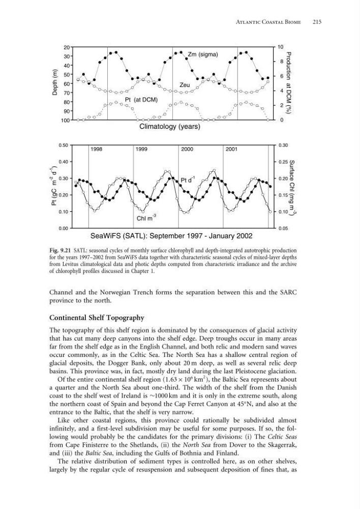
Fig. 9.21 SATL: seasonal cycles of monthly surface chlorophyll and depth-integrated autotrophic production
for the years 1997–2002 from SeaWiFS data together with characteristic seasonal cycles of mixed-layer depths
from Levitus climatological data and photic depths computed from characteristic irradiance and the archive
of chlorophyll profiles discussed in Chapter 1.
Channel and the Norwegian Trench forms the separation between this and the SARC
province to the north.
Continental Shelf Topography
The topography of this shelf region is dominated by the consequences of glacial activity
that has cut many deep canyons into the shelf edge. Deep troughs occur in many areas
far from the shelf edge as in the English Channel, and both relic and modern sand waves
occur commonly, as in the Celtic Sea. The North Sea has a shallow central region of
glacial deposits, the Dogger Bank, only about 20 m deep, as well as several relic deep
basins. This province was, in fact, mostly dry land during the last Pleistocene glaciation.
Of the entire continental shelf region (163 × 10
6 km
2 ), the Baltic Sea represents about
a quarter and the North Sea about one-third. The width of the shelf from the Danish
coast to the shelf west of Ireland is ∼1000 km and it is only in the extreme south, along
the northern coast of Spain and beyond the Cap Ferret Canyon at 45
N, and also at the
entrance to the Baltic, that the shelf is very narrow.
Like other coastal regions, this province could rationally be subdivided almost
infinitely, and a first-level subdivision may be useful for some purposes. If so, the following would probably be the candidates for the primary divisions: (i) The Celtic Seas
from Cape Finisterre to the Shetlands, (ii) the North Sea from Dover to the Skagerrak,
and (iii) the Baltic Sea, including the Gulfs of Bothnia and Finland.
The relative distribution of sediment types is controlled here, as on other shelves,
largely by the regular cycle of resuspension and subsequent deposition of fines that, as
215
20
30
40
50
60
70
80
90
100
0
2
4
6
8
10
Climatology (years)
Depth (m)
Production at DCM (%)
Zm (sigma)
Zeu
Pt (at DCM)
0.00
0.10
0.20
0.30
0.40
0.50
0.05
0.10
0.15
0.20
0.25
0.30
SeaWiFS (SATL): September 1997 - January 2002
Surface Chl (mg m
-3
)
Pt d
-1
Chl m
-3
1998
1999
2000
2001
Pt (gC m
-2
d
-1
)
Fig. 9.21 SATL: seasonal cycles of monthly surface chlorophyll and depth-integrated autotrophic production
for the years 1997–2002 from SeaWiFS data together with characteristic seasonal cycles of mixed-layer depths
from Levitus climatological data and photic depths computed from characteristic irradiance and the archive
of chlorophyll profiles discussed in Chapter 1.
Channel and the Norwegian Trench forms the separation between this and the SARC
province to the north.
Continental Shelf Topography
The topography of this shelf region is dominated by the consequences of glacial activity
that has cut many deep canyons into the shelf edge. Deep troughs occur in many areas
far from the shelf edge as in the English Channel, and both relic and modern sand waves
occur commonly, as in the Celtic Sea. The North Sea has a shallow central region of
glacial deposits, the Dogger Bank, only about 20 m deep, as well as several relic deep
basins. This province was, in fact, mostly dry land during the last Pleistocene glaciation.
Of the entire continental shelf region (163 × 10
6 km
2 ), the Baltic Sea represents about
a quarter and the North Sea about one-third. The width of the shelf from the Danish
coast to the shelf west of Ireland is ∼1000 km and it is only in the extreme south, along
the northern coast of Spain and beyond the Cap Ferret Canyon at 45
N, and also at the
entrance to the Baltic, that the shelf is very narrow.
Like other coastal regions, this province could rationally be subdivided almost
infinitely, and a first-level subdivision may be useful for some purposes. If so, the following would probably be the candidates for the primary divisions: (i) The Celtic Seas
from Cape Finisterre to the Shetlands, (ii) the North Sea from Dover to the Skagerrak,
and (iii) the Baltic Sea, including the Gulfs of Bothnia and Finland.
The relative distribution of sediment types is controlled here, as on other shelves,
largely by the regular cycle of resuspension and subsequent deposition of fines that, as