

Atlantic Trade Wind Biome
211
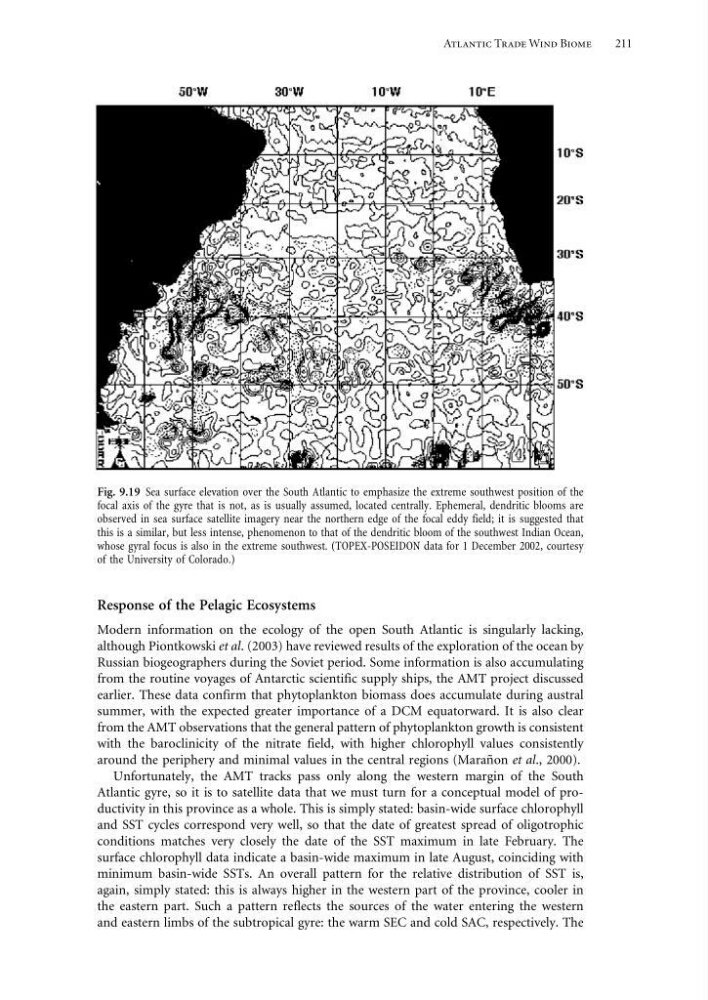
Fig. 9.19 Sea surface elevation over the South Atlantic to emphasize the extreme southwest position of the
focal axis of the gyre that is not, as is usually assumed, located centrally. Ephemeral, dendritic blooms are
observed in sea surface satellite imagery near the northern edge of the focal eddy field; it is suggested that
this is a similar, but less intense, phenomenon to that of the dendritic bloom of the southwest Indian Ocean,
whose gyral focus is also in the extreme southwest. (TOPEX-POSEIDON data for 1 December 2002, courtesy
of the University of Colorado.)
Response of the Pelagic Ecosystems
Modern information on the ecology of the open South Atlantic is singularly lacking,
although Piontkowski et al. (2003) have reviewed results of the exploration of the ocean by
Russian biogeographers during the Soviet period. Some information is also accumulating
from the routine voyages of Antarctic scientific supply ships, the AMT project discussed
earlier. These data confirm that phytoplankton biomass does accumulate during austral
summer, with the expected greater importance of a DCM equatorward. It is also clear
from the AMT observations that the general pattern of phytoplankton growth is consistent
with the baroclinicity of the nitrate field, with higher chlorophyll values consistently
around the periphery and minimal values in the central regions (Marañon et al., 2000).
Unfortunately, the AMT tracks pass only along the western margin of the South
Atlantic gyre, so it is to satellite data that we must turn for a conceptual model of productivity in this province as a whole. This is simply stated: basin-wide surface chlorophyll
and SST cycles correspond very well, so that the date of greatest spread of oligotrophic
conditions matches very closely the date of the SST maximum in late February. The
surface chlorophyll data indicate a basin-wide maximum in late August, coinciding with
minimum basin-wide SSTs. An overall pattern for the relative distribution of SST is,
again, simply stated: this is always higher in the western part of the province, cooler in
the eastern part. Such a pattern reflects the sources of the water entering the western
and eastern limbs of the subtropical gyre: the warm SEC and cold SAC, respectively. The
211
Fig. 9.19 Sea surface elevation over the South Atlantic to emphasize the extreme southwest position of the
focal axis of the gyre that is not, as is usually assumed, located centrally. Ephemeral, dendritic blooms are
observed in sea surface satellite imagery near the northern edge of the focal eddy field; it is suggested that
this is a similar, but less intense, phenomenon to that of the dendritic bloom of the southwest Indian Ocean,
whose gyral focus is also in the extreme southwest. (TOPEX-POSEIDON data for 1 December 2002, courtesy
of the University of Colorado.)
Response of the Pelagic Ecosystems
Modern information on the ecology of the open South Atlantic is singularly lacking,
although Piontkowski et al. (2003) have reviewed results of the exploration of the ocean by
Russian biogeographers during the Soviet period. Some information is also accumulating
from the routine voyages of Antarctic scientific supply ships, the AMT project discussed
earlier. These data confirm that phytoplankton biomass does accumulate during austral
summer, with the expected greater importance of a DCM equatorward. It is also clear
from the AMT observations that the general pattern of phytoplankton growth is consistent
with the baroclinicity of the nitrate field, with higher chlorophyll values consistently
around the periphery and minimal values in the central regions (Marañon et al., 2000).
Unfortunately, the AMT tracks pass only along the western margin of the South
Atlantic gyre, so it is to satellite data that we must turn for a conceptual model of productivity in this province as a whole. This is simply stated: basin-wide surface chlorophyll
and SST cycles correspond very well, so that the date of greatest spread of oligotrophic
conditions matches very closely the date of the SST maximum in late February. The
surface chlorophyll data indicate a basin-wide maximum in late August, coinciding with
minimum basin-wide SSTs. An overall pattern for the relative distribution of SST is,
again, simply stated: this is always higher in the western part of the province, cooler in
the eastern part. Such a pattern reflects the sources of the water entering the western
and eastern limbs of the subtropical gyre: the warm SEC and cold SAC, respectively. The