

204
Chapter 9: The Atlantic Ocean
Atlantic at about 6
S and thus very close to the Angola Gyre, on its northeast side.
The plume of the Congo is of strongly colored water and discharge is maximal in June
and December as water from different parts of the drainage basin reaches the sea. The
plume normally passes west or northwest across the northern part of the tropical gyre,
but during Benguela Niños, as in 1995, it may pass to the south along the shelf into
the BENG province (Gammelsrd et al., 1998). This plume is a prominent feature in the
surface pigment field of ETRA, whereas the smaller discharge from the Niger River into
the Bight of Biafra is much less consequential. The surface salinity signal of this discharge
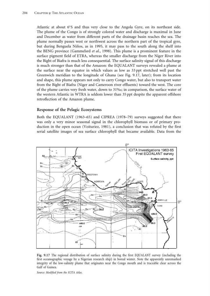
is much stronger than that of the Amazon: the EQUALANT surveys revealed a plume at
the surface near the equator in which values as low as 33 ppt stretched well past the
Greenwich meridian to the longitude of Ghana (see Fig. 9.17, later); from its location
and shape, this plume appears not only to carry Congo water, but also to transport water
from the Bight of Biafra (Niger and Cameroon river effluents) toward the west. The core
of the plume carries very fresh water, down to 31‰; in comparison, the surface water of
the western Atlantic in WTRA is seldom lower than 35 ppt despite the apparent offshore
retroflection of the Amazon plume.
Response of the Pelagic Ecosystems
Both the EQUALANT (1963–65) and CIPREA (1978–79) surveys suggested that there
was only a very minor seasonal signal in the chlorophyll biomass or of primary production in the open ocean (Voituriez, 1981), a conclusion that was refuted by the first
serial satellite images of sea surface chlorophyll that became available. Data from the
Fig. 9.17 The regional distribution of surface salinity during the first EQUALANT survey (including the
first oceanographic voyage by a Nigerian research ship) in boreal winter. Note the apparently unremarked
integrity of the low-salinity plume that originates near the Congo mouth and is traceable clear across the
Gulf of Guinea.
Source: Modified from the ICITA Atlas.
Chapter 9: The Atlantic Ocean
Atlantic at about 6
S and thus very close to the Angola Gyre, on its northeast side.
The plume of the Congo is of strongly colored water and discharge is maximal in June
and December as water from different parts of the drainage basin reaches the sea. The
plume normally passes west or northwest across the northern part of the tropical gyre,
but during Benguela Niños, as in 1995, it may pass to the south along the shelf into
the BENG province (Gammelsrd et al., 1998). This plume is a prominent feature in the
surface pigment field of ETRA, whereas the smaller discharge from the Niger River into
the Bight of Biafra is much less consequential. The surface salinity signal of this discharge
is much stronger than that of the Amazon: the EQUALANT surveys revealed a plume at
the surface near the equator in which values as low as 33 ppt stretched well past the
Greenwich meridian to the longitude of Ghana (see Fig. 9.17, later); from its location
and shape, this plume appears not only to carry Congo water, but also to transport water
from the Bight of Biafra (Niger and Cameroon river effluents) toward the west. The core
of the plume carries very fresh water, down to 31‰; in comparison, the surface water of
the western Atlantic in WTRA is seldom lower than 35 ppt despite the apparent offshore
retroflection of the Amazon plume.
Response of the Pelagic Ecosystems
Both the EQUALANT (1963–65) and CIPREA (1978–79) surveys suggested that there
was only a very minor seasonal signal in the chlorophyll biomass or of primary production in the open ocean (Voituriez, 1981), a conclusion that was refuted by the first
serial satellite images of sea surface chlorophyll that became available. Data from the
Fig. 9.17 The regional distribution of surface salinity during the first EQUALANT survey (including the
first oceanographic voyage by a Nigerian research ship) in boreal winter. Note the apparently unremarked
integrity of the low-salinity plume that originates near the Congo mouth and is traceable clear across the
Gulf of Guinea.
Source: Modified from the ICITA Atlas.