

202
Chapter 9: The Atlantic Ocean
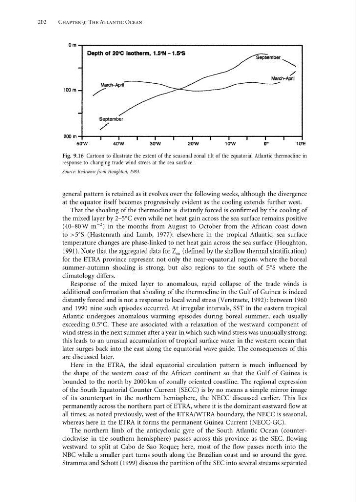
Fig. 9.16 Cartoon to illustrate the extent of the seasonal zonal tilt of the equatorial Atlantic thermocline in
response to changing trade wind stress at the sea surface.
Source: Redrawn from Houghton, 1983.
general pattern is retained as it evolves over the following weeks, although the divergence
at the equator itself becomes progressively evident as the cooling extends further west.
That the shoaling of the thermocline is distantly forced is confirmed by the cooling of
the mixed layer by 2–5
C even while net heat gain across the sea surface remains positive
(40–80 W m
−2 ) in the months from August to October from the African coast down
to >5
S (Hastenrath and Lamb, 1977): elsewhere in the tropical Atlantic, sea surface
temperature changes are phase-linked to net heat gain across the sea surface (Houghton,
1991). Note that the aggregated data for Z m (defined by the shallow thermal stratification)
for the ETRA province represent not only the near-equatorial regions where the boreal
summer-autumn shoaling is strong, but also regions to the south of 5
S where the
climatology differs.
Response of the mixed layer to anomalous, rapid collapse of the trade winds is
additional confirmation that shoaling of the thermocline in the Gulf of Guinea is indeed
distantly forced and is not a response to local wind stress (Verstraete, 1992): between 1960
and 1990 nine such episodes occurred. At irregular intervals, SST in the eastern tropical
Atlantic undergoes anomalous warming episodes during boreal summer, each usually
exceeding 05
C. These are associated with a relaxation of the westward component of
wind stress in the next summer after a year in which such wind stress was unusually strong;
this leads to an unusual accumulation of tropical surface water in the western ocean that
later surges back into the east along the equatorial wave guide. The consequences of this
are discussed later.
Here in the ETRA, the ideal equatorial circulation pattern is much influenced by
the shape of the western coast of the African continent so that the Gulf of Guinea is
bounded to the north by 2000 km of zonally oriented coastline. The regional expression
of the South Equatorial Counter Current (SECC) is by no means a simple mirror image
of its counterpart in the northern hemisphere, the NECC discussed earlier. This lies
permanently across the northern part of ETRA, where it is the dominant eastward flow at
all times; as noted previously, west of the ETRA/WTRA boundary, the NECC is seasonal,
whereas here in the ETRA it forms the permanent Guinea Current (NECC-GC).
The northern limb of the anticyclonic gyre of the South Atlantic Ocean (counterclockwise in the southern hemisphere) passes across this province as the SEC, flowing
westward to split at Cabo de Sao Roque; here, most of the flow passes north into the
NBC while a smaller part turns south along the Brazilian coast and so around the gyre.
Stramma and Schott (1999) discuss the partition of the SEC into several streams separated
Chapter 9: The Atlantic Ocean
Fig. 9.16 Cartoon to illustrate the extent of the seasonal zonal tilt of the equatorial Atlantic thermocline in
response to changing trade wind stress at the sea surface.
Source: Redrawn from Houghton, 1983.
general pattern is retained as it evolves over the following weeks, although the divergence
at the equator itself becomes progressively evident as the cooling extends further west.
That the shoaling of the thermocline is distantly forced is confirmed by the cooling of
the mixed layer by 2–5
C even while net heat gain across the sea surface remains positive
(40–80 W m
−2 ) in the months from August to October from the African coast down
to >5
S (Hastenrath and Lamb, 1977): elsewhere in the tropical Atlantic, sea surface
temperature changes are phase-linked to net heat gain across the sea surface (Houghton,
1991). Note that the aggregated data for Z m (defined by the shallow thermal stratification)
for the ETRA province represent not only the near-equatorial regions where the boreal
summer-autumn shoaling is strong, but also regions to the south of 5
S where the
climatology differs.
Response of the mixed layer to anomalous, rapid collapse of the trade winds is
additional confirmation that shoaling of the thermocline in the Gulf of Guinea is indeed
distantly forced and is not a response to local wind stress (Verstraete, 1992): between 1960
and 1990 nine such episodes occurred. At irregular intervals, SST in the eastern tropical
Atlantic undergoes anomalous warming episodes during boreal summer, each usually
exceeding 05
C. These are associated with a relaxation of the westward component of
wind stress in the next summer after a year in which such wind stress was unusually strong;
this leads to an unusual accumulation of tropical surface water in the western ocean that
later surges back into the east along the equatorial wave guide. The consequences of this
are discussed later.
Here in the ETRA, the ideal equatorial circulation pattern is much influenced by
the shape of the western coast of the African continent so that the Gulf of Guinea is
bounded to the north by 2000 km of zonally oriented coastline. The regional expression
of the South Equatorial Counter Current (SECC) is by no means a simple mirror image
of its counterpart in the northern hemisphere, the NECC discussed earlier. This lies
permanently across the northern part of ETRA, where it is the dominant eastward flow at
all times; as noted previously, west of the ETRA/WTRA boundary, the NECC is seasonal,
whereas here in the ETRA it forms the permanent Guinea Current (NECC-GC).
The northern limb of the anticyclonic gyre of the South Atlantic Ocean (counterclockwise in the southern hemisphere) passes across this province as the SEC, flowing
westward to split at Cabo de Sao Roque; here, most of the flow passes north into the
NBC while a smaller part turns south along the Brazilian coast and so around the gyre.
Stramma and Schott (1999) discuss the partition of the SEC into several streams separated