

188
Chapter 9: The Atlantic Ocean
0
20
40
60
80
100
0
5
10
15
20
25
30
35
Climatology (years)
Depth (m)
Production at DCM (%)
Zm (sigma)
Zeu
Pt (at DCM)
0.24
0.30
0.36
0.42
0.48
0.10
0.15
0.20
0.25
0.30
0.35
SeaWiFS (NATR): September 1997 - January 2002
Surface Chl (mg m -3
)
Pt d
-1
Chl m
-3
Pt (gC m
-2
d
-1
)
1998
1999
2000
2001
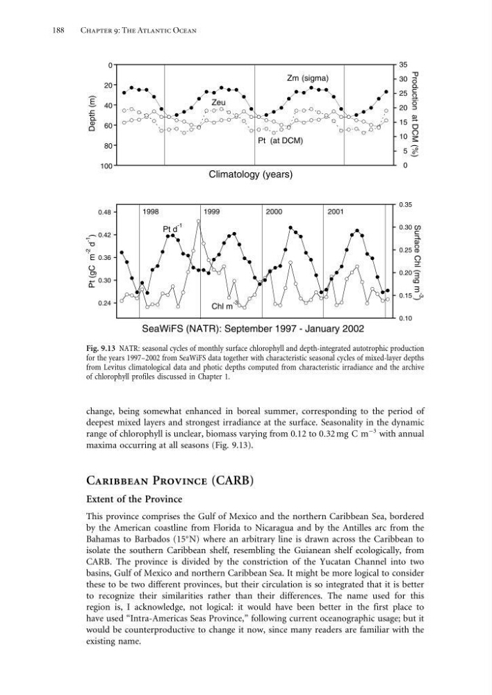
Fig. 9.13 NATR: seasonal cycles of monthly surface chlorophyll and depth-integrated autotrophic production
for the years 1997–2002 from SeaWiFS data together with characteristic seasonal cycles of mixed-layer depths
from Levitus climatological data and photic depths computed from characteristic irradiance and the archive
of chlorophyll profiles discussed in Chapter 1.
change, being somewhat enhanced in boreal summer, corresponding to the period of
deepest mixed layers and strongest irradiance at the surface. Seasonality in the dynamic
range of chlorophyll is unclear, biomass varying from 0.12 to 032 mg C m
−3 with annual
maxima occurring at all seasons (Fig. 9.13).
Caribbean Province (CARB)
Extent of the Province
This province comprises the Gulf of Mexico and the northern Caribbean Sea, bordered
by the American coastline from Florida to Nicaragua and by the Antilles arc from the
Bahamas to Barbados (15
N) where an arbitrary line is drawn across the Caribbean to
isolate the southern Caribbean shelf, resembling the Guianean shelf ecologically, from
CARB. The province is divided by the constriction of the Yucatan Channel into two
basins, Gulf of Mexico and northern Caribbean Sea. It might be more logical to consider
these to be two different provinces, but their circulation is so integrated that it is better
to recognize their similarities rather than their differences. The name used for this
region is, I acknowledge, not logical: it would have been better in the first place to
have used “Intra-Americas Seas Province,” following current oceanographic usage; but it
would be counterproductive to change it now, since many readers are familiar with the
existing name.
Chapter 9: The Atlantic Ocean
0
20
40
60
80
100
0
5
10
15
20
25
30
35
Climatology (years)
Depth (m)
Production at DCM (%)
Zm (sigma)
Zeu
Pt (at DCM)
0.24
0.30
0.36
0.42
0.48
0.10
0.15
0.20
0.25
0.30
0.35
SeaWiFS (NATR): September 1997 - January 2002
Surface Chl (mg m -3
)
Pt d
-1
Chl m
-3
Pt (gC m
-2
d
-1
)
1998
1999
2000
2001
Fig. 9.13 NATR: seasonal cycles of monthly surface chlorophyll and depth-integrated autotrophic production
for the years 1997–2002 from SeaWiFS data together with characteristic seasonal cycles of mixed-layer depths
from Levitus climatological data and photic depths computed from characteristic irradiance and the archive
of chlorophyll profiles discussed in Chapter 1.
change, being somewhat enhanced in boreal summer, corresponding to the period of
deepest mixed layers and strongest irradiance at the surface. Seasonality in the dynamic
range of chlorophyll is unclear, biomass varying from 0.12 to 032 mg C m
−3 with annual
maxima occurring at all seasons (Fig. 9.13).
Caribbean Province (CARB)
Extent of the Province
This province comprises the Gulf of Mexico and the northern Caribbean Sea, bordered
by the American coastline from Florida to Nicaragua and by the Antilles arc from the
Bahamas to Barbados (15
N) where an arbitrary line is drawn across the Caribbean to
isolate the southern Caribbean shelf, resembling the Guianean shelf ecologically, from
CARB. The province is divided by the constriction of the Yucatan Channel into two
basins, Gulf of Mexico and northern Caribbean Sea. It might be more logical to consider
these to be two different provinces, but their circulation is so integrated that it is better
to recognize their similarities rather than their differences. The name used for this
region is, I acknowledge, not logical: it would have been better in the first place to
have used “Intra-Americas Seas Province,” following current oceanographic usage; but it
would be counterproductive to change it now, since many readers are familiar with the
existing name.