

Atlantic Polar Biome
143
0.00
0.30
0.60
0.90
1.20
1.50
0.00
0.50
1.00
1.50
2.00
2.50
SeaWiFS (BPLR): September 1997 - January 2002
Surface Chl (mg m -3
)
Pt (gC m
-2
d
-1
)
Pt d
-1
Chl m
-3
1998
1999
2000
2001
0
20
40
60
80
100
0
5
10
15
20
Climatology (years)
Depth (m)
Production at DCM (% )
Zm (sigma)
Zeu
Pt (at DCM)
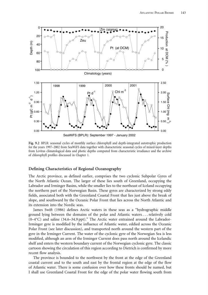
Fig. 9.2 BPLR: seasonal cycles of monthly surface chlorophyll and depth-integrated autotrophic production
for the years 1997–2002 from SeaWiFS data together with characteristic seasonal cycles of mixed-layer depths
from Levitus climatological data and photic depths computed from characteristic irradiance and the archive
of chlorophyll profiles discussed in Chapter 1.
Defining Characteristics of Regional Oceanography
The Arctic province, as defined earlier, comprises the two cyclonic Subpolar Gyres of
the North Atlantic Ocean. The larger of these lies south of Greenland, occupying the
Labrador and Irminger Basins, while the smaller lies to the northeast of Iceland occupying
the northern part of the Norwegian Basin. These gyres are characterized by strong eddy
fields, associated both with the Greenland Coastal Front that lies just above the break of
slope, and southward by the Oceanic Polar Front that lies across the North Atlantic and
its extension into the Nordic seas.
James Swift (1986) defines Arctic waters in these seas as a “hydrographic middle
ground lying between the domains of the polar and Atlantic waters relatively cold
(0–4
C) and saline (34.6–34.9 ppt).” The Arctic water entrained around the LabradorIrminger gyre is modified by the influence of Atlantic water, eddied across the Oceanic
Polar Front (see later discussion), and transported north around the western part of the
gyre in the Irminger Current. The water of the cyclonic gyre of the Norwegian Sea is less
modified, although an arm of the Irminger Current does pass north around the Icelandic
shelf and enters the western boundary current of the Norwegian cyclonic gyre. The classic
cartoon showing the circulation of this region according to Dietrich is confirmed by more
recent flow analysis.
The province is bounded to the northwest by the front at the edge of the Greenland
coastal current and to the south and east by the frontal region at the edge of the flow
of Atlantic water. There is some confusion over how these fronts should be named, but
I shall use Greenland Coastal Front for the edge of the polar water flowing south from
143
0.00
0.30
0.60
0.90
1.20
1.50
0.00
0.50
1.00
1.50
2.00
2.50
SeaWiFS (BPLR): September 1997 - January 2002
Surface Chl (mg m -3
)
Pt (gC m
-2
d
-1
)
Pt d
-1
Chl m
-3
1998
1999
2000
2001
0
20
40
60
80
100
0
5
10
15
20
Climatology (years)
Depth (m)
Production at DCM (% )
Zm (sigma)
Zeu
Pt (at DCM)
Fig. 9.2 BPLR: seasonal cycles of monthly surface chlorophyll and depth-integrated autotrophic production
for the years 1997–2002 from SeaWiFS data together with characteristic seasonal cycles of mixed-layer depths
from Levitus climatological data and photic depths computed from characteristic irradiance and the archive
of chlorophyll profiles discussed in Chapter 1.
Defining Characteristics of Regional Oceanography
The Arctic province, as defined earlier, comprises the two cyclonic Subpolar Gyres of
the North Atlantic Ocean. The larger of these lies south of Greenland, occupying the
Labrador and Irminger Basins, while the smaller lies to the northeast of Iceland occupying
the northern part of the Norwegian Basin. These gyres are characterized by strong eddy
fields, associated both with the Greenland Coastal Front that lies just above the break of
slope, and southward by the Oceanic Polar Front that lies across the North Atlantic and
its extension into the Nordic seas.
James Swift (1986) defines Arctic waters in these seas as a “hydrographic middle
ground lying between the domains of the polar and Atlantic waters relatively cold
(0–4
C) and saline (34.6–34.9 ppt).” The Arctic water entrained around the LabradorIrminger gyre is modified by the influence of Atlantic water, eddied across the Oceanic
Polar Front (see later discussion), and transported north around the western part of the
gyre in the Irminger Current. The water of the cyclonic gyre of the Norwegian Sea is less
modified, although an arm of the Irminger Current does pass north around the Icelandic
shelf and enters the western boundary current of the Norwegian cyclonic gyre. The classic
cartoon showing the circulation of this region according to Dietrich is confirmed by more
recent flow analysis.
The province is bounded to the northwest by the front at the edge of the Greenland
coastal current and to the south and east by the frontal region at the edge of the flow
of Atlantic water. There is some confusion over how these fronts should be named, but
I shall use Greenland Coastal Front for the edge of the polar water flowing south from